
What map do we make to represent the Roman Empire? How did they imagine it?
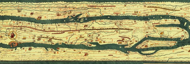
The Roman government habitually understood itself not as controlling a homogeneous space—terrain—but as coordinating a collective of cities. That may seem strange, but consider the only visual representation of the empire, from the empire, that we have— or, rather, a 13th-century copy of it. It’s a map called the Peutinger Table, and you need only to glance at it to appreciate how the Roman political imagination could flatten the diversity of landscapes on three continents to accommodate a vision of the empire as an extended network of cities and roads connecting them. To us, it looks less like a topographical map, a map of space, and more like a subway map.
